
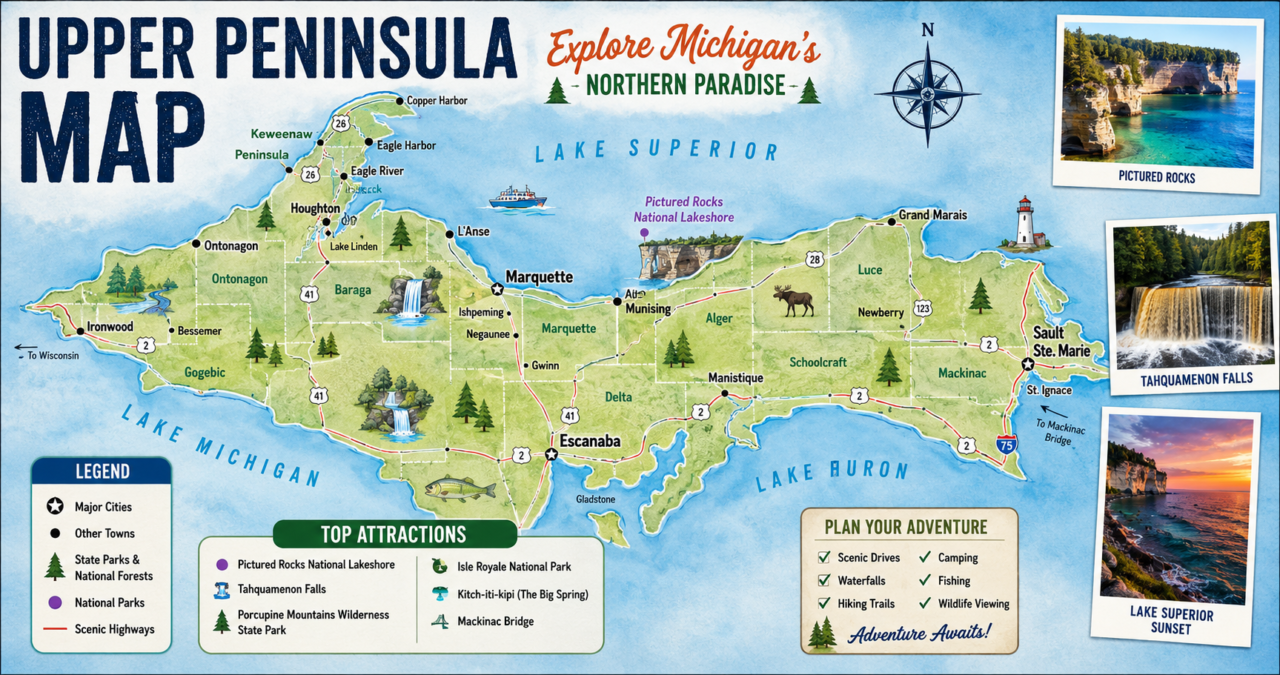

The Upper Peninsula map is much more than a simple navigation tool. It serves as a gateway to one of the most scenic and adventurous regions in the United States. Whether you’re planning a road trip, searching for waterfalls, exploring state parks, or visiting charming lakeside towns, understanding the layout of Michigan’s Upper Peninsula helps you make the most of your journey. Stretching between Lake Superior, Lake Michigan, and Lake Huron, the Upper Peninsula—often called the U.P.—offers a blend of wilderness, history, and outdoor recreation that is unlike anywhere else.
Many travelers underestimate just how large and diverse the region is. Looking at an Upper Peninsula map reveals vast forests, hundreds of miles of shoreline, countless inland lakes, and small communities connected by scenic highways. Every section of the peninsula has something unique to offer, from dramatic cliffs overlooking Lake Superior to peaceful hiking trails deep within national forests. A detailed map helps visitors discover attractions they might otherwise miss.
Understanding the geography of the Upper Peninsula is especially important because destinations are often spread far apart. Planning your routes in advance saves time and allows you to experience more of what makes the region special. Whether you’re interested in camping, fishing, photography, skiing, or simply enjoying breathtaking landscapes, a good map becomes one of your most valuable travel companions.
This comprehensive guide explains everything you need to know about reading an Upper Peninsula map, identifying important regions, locating major attractions, understanding transportation routes, and planning unforgettable adventures throughout Michigan’s northern paradise.
Understanding the Upper Peninsula Map
An Upper Peninsula map provides an overview of Michigan’s northern landmass, which is separated from the Lower Peninsula by the Straits of Mackinac. While many people think of Michigan as a single peninsula, the state actually consists of two distinct peninsulas connected by the famous Mackinac Bridge.
The Upper Peninsula stretches roughly 320 miles from east to west and nearly 125 miles from north to south. Although the population is relatively small compared to the Lower Peninsula, the region covers an enormous amount of land. Much of this area remains undeveloped, making maps incredibly useful for travelers who want to navigate forests, lakes, rivers, and remote communities safely.
Unlike city maps that focus on streets and neighborhoods, an Upper Peninsula map highlights natural landmarks, scenic highways, recreational areas, national forests, state parks, waterfalls, and coastal destinations. These features help visitors understand how the region is organized and make trip planning significantly easier.
The map also illustrates how geography shapes everyday life in the U.P. Many communities are built along the shores of Lake Superior, Lake Michigan, or Lake Huron, while large stretches of forest separate one town from another. Appreciating these distances allows travelers to prepare realistic itineraries without feeling rushed.
Where Is Michigan’s Upper Peninsula Located?
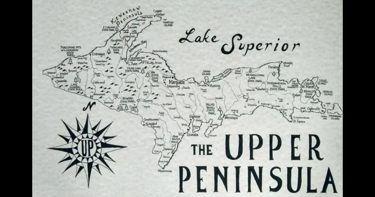
The Upper Peninsula Map occupies the northernmost portion of Michigan. It lies between Wisconsin to the west and Canada across Lake Superior to the north. Lake Michigan borders the south, while Lake Huron stretches along portions of the eastern shoreline.
Looking at an Upper Peninsula map, you’ll notice that water surrounds much of the region. This unique geography influences everything from weather patterns to outdoor activities. The Great Lakes create stunning coastlines, sandy beaches, rocky cliffs, historic lighthouses, and countless opportunities for boating, kayaking, and fishing.
The Mackinac Bridge serves as the primary connection between Michigan’s Upper and Lower Peninsulas. Travelers entering from the south usually cross this iconic suspension bridge before beginning their adventure across the U.P. From there, highways branch westward toward forests, waterfalls, and charming small towns.
The region also shares a land border with Wisconsin, making it accessible from neighboring Midwestern states. This location allows visitors to combine trips through Wisconsin and Michigan while exploring some of the most beautiful natural landscapes in North America.
Why an Upper Peninsula Map Is Essential for Travelers
Many first-time visitors assume they can rely entirely on smartphone navigation. While GPS works well in populated areas, portions of the Upper Peninsula have limited or inconsistent mobile coverage. Carrying a printed Upper Peninsula map or downloading offline maps provides peace of mind when traveling through remote forests and parks.
A detailed map also encourages exploration beyond the most popular tourist destinations. Instead of simply following GPS directions, travelers can discover scenic byways, hidden beaches, quiet campgrounds, and lesser-known waterfalls located just off the main highways.
Planning daily travel becomes much easier with a physical overview of the region. Because attractions may be separated by long driving distances, maps help organize efficient routes while reducing unnecessary backtracking.
Maps are equally valuable for outdoor enthusiasts. Hikers, campers, snowmobilers, anglers, and hunters frequently venture into areas where road signs are limited. Having reliable navigation improves both convenience and safety throughout the journey.
Regions Found on an Upper Peninsula Map
The Upper Peninsula is commonly divided into several distinct geographic regions. Each offers unique landscapes, attractions, and recreational opportunities that appeal to different types of travelers.
The eastern portion includes communities near the Mackinac Bridge and Lake Huron. This area is known for picturesque shorelines, historic sites, and easy access for visitors arriving from the Lower Peninsula.
The central region features dense forests, inland lakes, and numerous outdoor recreation opportunities. National forests dominate much of the landscape, making this area popular for hiking, camping, wildlife viewing, and off-road adventures.
Western sections of the Upper Peninsula showcase rugged mountains, mining history, dramatic waterfalls, and spectacular Lake Superior scenery. Many travelers consider this area among the most beautiful portions of the Midwest.
The northern shoreline follows Lake Superior and contains towering cliffs, rocky beaches, and unforgettable viewpoints. On any Upper Peninsula map, this coastline stands out as one of the region’s greatest natural treasures.
Major Cities You’ll Find on an Upper Peninsula Map
Although much of the Upper Peninsula is rural, several cities serve as important centers for tourism, lodging, dining, and recreation.
Marquette is the largest city in the Upper Peninsula and functions as a cultural and economic hub. Visitors often use it as a base for exploring nearby waterfalls, hiking trails, beaches, and Lake Superior attractions. The city combines outdoor adventure with restaurants, breweries, museums, and shopping.
Sault Ste. Marie sits at the eastern edge of the peninsula near the Soo Locks. This historic city attracts visitors interested in maritime history, engineering, and international shipping. It also serves as an important gateway to Canada.
Escanaba lies along Little Bay de Noc and offers beautiful waterfront parks, fishing opportunities, and easy access to southern portions of the U.P. Its central location makes it a convenient stop during longer road trips.
Iron Mountain, Houghton, Hancock, Munising, Ironwood, and Menominee each contribute unique experiences ranging from mining heritage to skiing, waterfalls, and waterfront recreation. Studying an Upper Peninsula map helps travelers determine which communities best fit their itinerary and interests.
Counties Shown on an Upper Peninsula Map
Michigan’s Upper Peninsula consists of fifteen counties, each with its own personality and attractions. Understanding county boundaries helps travelers navigate regional services, parks, campgrounds, and local attractions more effectively.
Keweenaw County occupies the northern tip of the Keweenaw Peninsula and is famous for rugged coastlines, historic mining communities, and excellent opportunities for hiking and photography. Nearby Houghton County offers additional outdoor adventures along with a vibrant university atmosphere.
Alger County is widely recognized for its waterfalls, forests, and the breathtaking Pictured Rocks National Lakeshore. Schoolcraft County contains expansive wilderness areas and peaceful stretches of Lake Michigan shoreline.
Marquette County serves as one of the region’s busiest destinations thanks to its combination of urban amenities and natural beauty. Gogebic County in the west attracts visitors seeking skiing, snowmobiling, and year-round outdoor recreation.
Other counties—including Chippewa, Mackinac, Delta, Dickinson, Iron, Baraga, Ontonagon, Luce, Menominee, and Ontonagon—each contribute unique attractions that become easier to locate using a detailed Upper Peninsula map.
The Great Lakes Surrounding the Upper Peninsula
One of the first things you’ll notice on an Upper Peninsula map is how completely the region is defined by water. Three of the five Great Lakes surround the peninsula, creating thousands of miles of coastline and countless opportunities for recreation.
Lake Superior dominates the northern edge of the peninsula. As the largest freshwater lake in the world by surface area, it offers dramatic cliffs, crystal-clear water, rocky beaches, and unforgettable sunsets. Many of the Upper Peninsula’s most famous attractions are located along this shoreline.
Lake Michigan borders the southern side of the peninsula. Its calmer waters, sandy beaches, and family-friendly recreation areas make it popular for camping, swimming, boating, and fishing during the warmer months.
Lake Huron shapes the eastern edge of the region near the Mackinac Bridge and the Les Cheneaux Islands. Its protected bays and scenic waterfront communities provide a quieter contrast to the rugged beauty of Lake Superior.
Together, these lakes influence everything from climate and wildlife to tourism and local culture. Understanding their locations on an Upper Peninsula map helps travelers appreciate just how unique this remarkable region truly is.
National Parks and Protected Areas on an Upper Peninsula Map
One of the biggest advantages of using an Upper Peninsula map is that it clearly shows where the region’s protected lands are located. Michigan’s Upper Peninsula is home to some of the country’s most breathtaking natural areas, many of which are preserved for future generations. These destinations attract hikers, photographers, campers, kayakers, and anyone who appreciates unspoiled landscapes.
Protected lands also help preserve wildlife habitats, forests, waterfalls, and shorelines. Instead of concentrating tourism in one area, these parks spread visitors across the peninsula, allowing travelers to experience different environments. Whether you’re planning a weekend getaway or a week-long road trip, locating these destinations on an Upper Peninsula map makes planning much easier.
Pictured Rocks National Lakeshore
One of the first places travelers search for on an Upper Peninsula map is Pictured Rocks National Lakeshore. Located along the southern shore of Lake Superior, this protected area is famous for colorful sandstone cliffs, sea caves, sandy beaches, waterfalls, and forest trails.
Visitors can experience the area by hiking, kayaking, taking scenic boat cruises, or simply enjoying the panoramic overlooks. Every season brings a different perspective, making it one of Michigan’s most photographed destinations. During autumn, colorful foliage transforms the cliffs into an unforgettable landscape.
Isle Royale National Park
Far from the mainland sits Isle Royale National Park, one of America’s least-visited yet most spectacular national parks. Although reaching the island requires a ferry or seaplane, many visitors consider it the highlight of their Upper Peninsula adventure.
On an Upper Peninsula map, Isle Royale appears isolated in Lake Superior, emphasizing its remote wilderness. The island offers backpacking, canoeing, kayaking, wildlife viewing, fishing, and exceptional opportunities to disconnect from modern life. Because vehicle traffic is nonexistent, visitors experience nature in its purest form.
State Parks Worth Finding on an Upper Peninsula Map
Beyond the national parks, Michigan’s Upper Peninsula contains numerous state parks that showcase diverse landscapes. These parks are ideal for camping, hiking, swimming, snowshoeing, and family vacations.
Many travelers use an Upper Peninsula map to connect several state parks into one scenic road trip. Since each park offers different natural features, exploring multiple locations provides a broader understanding of the region’s incredible diversity.
Porcupine Mountains Wilderness State Park stands out for its old-growth forests, mountain ridges, waterfalls, and Lake Superior views. Tahquamenon Falls State Park attracts visitors with one of the largest waterfalls east of the Mississippi River. McLain State Park offers beautiful beaches, while Van Riper State Park provides excellent camping opportunities surrounded by forests.
Each park contributes something unique, making the Upper Peninsula one of the Midwest’s premier outdoor destinations.
Famous Waterfalls Marked on an Upper Peninsula Map
The Upper Peninsula is often called Michigan’s waterfall capital. More than 300 waterfalls are scattered throughout forests, state parks, and remote wilderness areas. A detailed Upper Peninsula map helps visitors locate both famous falls and lesser-known natural wonders.
Waterfalls remain one of the region’s most popular attractions because they are accessible throughout much of the year. Spring snowmelt creates powerful cascades, summer offers lush green scenery, autumn adds brilliant foliage, and winter transforms many waterfalls into frozen works of art.
Tahquamenon Falls consistently ranks among the most famous. The Upper Falls impress visitors with their enormous size and distinctive amber-colored water, while the Lower Falls provide a quieter experience with walking trails and small islands.
Munising Falls, Miners Falls, Bond Falls, Agate Falls, Laughing Whitefish Falls, and Hungarian Falls are also frequently highlighted on an Upper Peninsula map. Together, these waterfalls create endless opportunities for photography and hiking.
Scenic Highways Across the Upper Peninsula
Driving is one of the best ways to experience the Upper Peninsula. Unlike heavily populated urban regions, the U.P. offers peaceful highways winding through forests, along lakeshores, and across rolling hills. An Upper Peninsula map helps travelers identify scenic routes rather than simply choosing the fastest roads.
Many visitors intentionally slow their journey because every stretch of highway reveals new landscapes. Small towns, roadside waterfalls, historic bridges, and breathtaking overlooks encourage frequent stops. Instead of rushing from one attraction to another, travelers often find that the drive itself becomes part of the adventure.
Highway M-28 serves as one of the peninsula’s primary east-west routes, connecting numerous communities and attractions. US-41 provides access to Marquette, the Keweenaw Peninsula, and Copper Harbor while passing through forests and historic mining districts.
M-123, M-26, and several county roads also appear prominently on an Upper Peninsula map, guiding travelers toward hidden beaches, state parks, and scenic viewpoints rarely found on ordinary travel itineraries.
Forests and Wilderness Areas
Much of Michigan’s Upper Peninsula remains covered by forests. Looking at an Upper Peninsula map, you’ll notice vast green areas representing millions of acres of protected woodland. These forests support wildlife, outdoor recreation, and sustainable forestry while preserving the region’s natural beauty.
Large forested areas create opportunities for hiking, hunting, fishing, camping, birdwatching, and cross-country skiing. Because many roads pass through these forests, travelers constantly encounter scenic landscapes that change dramatically with the seasons.
The Ottawa National Forest covers much of the western Upper Peninsula. It features rivers, lakes, waterfalls, and thousands of miles of trails suitable for hiking, biking, snowmobiling, and ATV riding.
The Hiawatha National Forest stretches across the eastern and central portions of the peninsula. Campgrounds, scenic drives, canoe routes, and quiet wilderness areas make it one of the most popular destinations shown on an Upper Peninsula map.
Beautiful Lakes Found Throughout the Region
Although the Great Lakes receive most of the attention, the Upper Peninsula also contains thousands of inland lakes. Many of these peaceful destinations appear on a detailed Upper Peninsula map, providing endless opportunities for boating, kayaking, paddleboarding, swimming, and fishing.
Some lakes are easily accessible by paved roads, while others require hiking or canoeing to reach. This variety allows every visitor to find an experience that matches their interests.
Lake Gogebic is the largest inland lake in the Upper Peninsula and is well known for fishing and boating. Big Manistique Lake attracts anglers throughout the year, while Lake Michigamme offers quiet scenery surrounded by forests.
Smaller lakes scattered throughout the region provide excellent wildlife viewing and peaceful camping experiences away from crowded tourist destinations.
Rivers That Shape the Upper Peninsula
Rivers play an important role in the geography displayed on an Upper Peninsula map. Flowing through forests and valleys, these waterways connect lakes, support wildlife, and create many of the waterfalls that attract visitors each year.
Several rivers are popular for canoeing, kayaking, rafting, and fishing. Others simply provide scenic beauty as they wind through remote wilderness.
The Tahquamenon River is perhaps the most famous because it feeds Tahquamenon Falls. The Menominee River forms part of Michigan’s border with Wisconsin and offers exciting whitewater rafting opportunities.
The Ontonagon River, Escanaba River, and Sturgeon River also contribute to the peninsula’s outdoor recreation while adding to its rich natural landscape.
Camping Opportunities Across the Upper Peninsula
Camping remains one of the best ways to experience the region’s natural beauty. An Upper Peninsula map identifies hundreds of campgrounds ranging from modern facilities with electrical hookups to primitive wilderness sites accessible only by hiking or canoe.
State parks provide family-friendly camping with nearby beaches, playgrounds, and hiking trails. National forests offer quieter settings surrounded by towering trees and peaceful lakes.
Dispersed camping is also available in many public lands, allowing experienced campers to enjoy true wilderness experiences. Because campsites are spread across the peninsula, maps help visitors choose locations close to waterfalls, scenic overlooks, fishing spots, or hiking trails.
Whether traveling by tent, camper, or RV, using an Upper Peninsula map simplifies campground selection and route planning.
Hiking Trails Every Nature Lover Should Explore
Hiking is one of the most rewarding activities available in Michigan’s Upper Peninsula. Trails range from short waterfall walks suitable for families to challenging multi-day backpacking adventures through remote wilderness.
Many trailheads are marked on an Upper Peninsula map, making it easier for visitors to organize outdoor excursions without missing hidden gems.
Popular hikes include the Chapel Loop, Escarpment Trail, Bare Bluff Trail, Sugarloaf Mountain, and Mount Arvon, Michigan’s highest point. These trails showcase cliffs, forests, lakes, waterfalls, and panoramic viewpoints that highlight the incredible diversity of the peninsula.
Regardless of experience level, hikers can find trails that match their abilities while enjoying some of the Midwest’s finest natural scenery.
Wildlife You May Encounter
Nature lovers often study an Upper Peninsula map to locate wildlife viewing areas before beginning their trip. Because much of the region remains undeveloped, animals thrive throughout forests, wetlands, rivers, and lakes.
White-tailed deer are commonly seen along roadsides, while black bears inhabit many forested areas. Moose occasionally appear in northern sections, though sightings remain relatively rare.
Birdwatchers may observe bald eagles, loons, owls, hawks, sandhill cranes, and countless migratory species depending on the season. Rivers and lakes support beavers, otters, turtles, and numerous fish species.
Responsible wildlife viewing means maintaining safe distances, avoiding feeding animals, and respecting protected habitats throughout the Upper Peninsula.
Conclusion
An Upper Peninsula map is much more than a navigation aid—it is the key to unlocking one of Michigan’s most spectacular destinations. From the rugged shoreline of Lake Superior to peaceful inland lakes, dense forests, scenic highways, charming small towns, and breathtaking waterfalls, the map reveals just how diverse and expansive the Upper Peninsula truly is. Whether you’re planning a weekend getaway or a longer road trip, understanding the region’s layout helps you make the most of every mile.
Using a detailed Upper Peninsula map allows travelers to confidently explore famous attractions while also discovering hidden gems that many visitors overlook. It simplifies route planning, highlights outdoor recreation opportunities, and ensures you don’t miss the incredible parks, trails, campgrounds, and historic sites scattered throughout the region.
No matter the season, the Upper Peninsula offers unforgettable experiences. Summer brings hiking, kayaking, and camping, autumn paints the forests with vibrant colors, winter transforms the landscape into a snowy playground, and spring fills rivers and waterfalls with powerful flows. With a reliable map in hand, every journey becomes easier, safer, and far more rewarding.
If you’re dreaming of an adventure surrounded by natural beauty, rich history, and endless outdoor activities, keeping an Upper Peninsula map close by is one of the smartest decisions you can make. It’s your guide to exploring one of the Midwest’s most remarkable destinations and creating memories that will last a lifetime.
Frequently Asked Questions
What is the Upper Peninsula map used for?
An Upper Peninsula map helps travelers locate cities, highways, state parks, waterfalls, lakes, campgrounds, hiking trails, and major attractions throughout Michigan’s Upper Peninsula. It is an essential planning tool for road trips and outdoor adventures.
Is a paper Upper Peninsula map better than GPS?
Both have advantages. GPS provides turn-by-turn navigation, while a paper Upper Peninsula map offers a complete overview of the region and remains reliable in remote areas where mobile service may be limited. Many experienced travelers carry both.
What are the must-see attractions on an Upper Peninsula map?
Some of the most popular destinations include Pictured Rocks National Lakeshore, Tahquamenon Falls, Porcupine Mountains Wilderness State Park, Copper Harbor, Marquette, Mackinac Bridge, Isle Royale National Park, and numerous scenic waterfalls and hiking trails.
How many counties are included in Michigan’s Upper Peninsula?
Michigan’s Upper Peninsula consists of 15 counties. Each county offers its own unique attractions, including forests, lakes, waterfalls, historic mining communities, and beautiful Great Lakes shorelines.
When is the best time to visit the Upper Peninsula?
The best time depends on your interests. Summer is ideal for hiking, camping, and boating, autumn offers spectacular fall colors, winter is perfect for skiing and snowmobiling, while spring features rushing waterfalls and fewer crowds. The Upper Peninsula map is useful year-round for planning seasonal adventures.
YOU MAY READ ALSO
Upper Peninsula Map: Complete Travel Guide, Attractions & Routes